 |
|
 |
|
La Storia dei
Vichinghi - I Vichinghi in America e gli
Skraelings
|
|
|
|
VICHINGHI - LE DRAKKAR
- GLI SKRAELINGS |
Le popolazioni vichinghe vengono alla ribalta della cronaca storica verso la
fine degli anni dell’ottavo secolo Dopo Cristo, nel momento in cui vengono a
contatto con le popolazioni europee. La storia conosciuta ed in parte
documentata di questo popolo è scritta soprattutto da coloro che si sono stati
vittime dei vichinghi. L’iconografia tramandata ci presenta dei giganti biondi
venuti dalle sconosciute terre del nord che roteavano grosse spade come
fuscelli, che saltavano a riva dalle loro navi, dalle prue scolpite a forma di
serpenti o draghi, le issavano in spiaggia e correvano urlando, seminando morte
e distruzione, orrore e saccheggio senza risparmiare niente e nessuno. Le
cronache dell’epoca hanno enfatizzato la ferocia dei popoli del nord tanto
quanto gli storici nazionalisti del diciannovesimo secolo ne hanno
marginalizzato il ruolo politico a favore di una centralità della Francia,
prima, e dell’impero e del Papato dopo. I vichinghi sono stati indicati come una
forza negativa e distruttiva che demolì la civiltà dell’occidente e segnando il
suo declino. Gli storici tradizionalisti hanno tralasciato le altre cause
distruttrici in gioco nell’Europa dell’epoca, in particolare le varie guerre tra
popolazioni. I luoghi di origine dei vichinghi sono stati individuati nella
penisola scandinava e nella parte europea che si affaccia sul Mar Baltico;
l’odierna Danimarca, Estonia; non si trattava di un unico popolo ma di un
insieme di tribù accomunati dal luogo cui abitavano, la lingua di comune
origine, lo stesso tipo di arte e cultura, modo di vivere e religione. Erano
navigatori, pescatori, allevatori ed agricoltori a seconda della conformazione
del territorio, ma anche commercianti: sono state rinvenute molte monete
islamiche orientali nel sito di Birka, circa 50 miglia dall’attuale Stoccolma.
Il sistema legislativo ci è giunto tramite le raccolte di scrittori romantici
del XIX secolo e la stratificazione sociale prevedeva il re, gli uomini liberi e
gli schiavi. I territori erano gestiti dai proprietari terrieri mediante
assemblee di uomini liberi dette thing. La causa dell’irrompere sulla scena
storica dei vichinghi è tuttora incerta, non provata da testimonianze certe. Si
va dall’ipotesi di un esplosione demografica con conseguente sovrappopolazione,
ad una società maschile dove la poligamia era abbondantemente praticata, un
clima favorevole che iniziò abbondante produzione agricola, nuovi strumenti di
lavoro ed utilizzo di terre circostanti disponibili. Quando questi cambiamenti
che rispondevano alla crescita della popolazione, ma contribuivano anche a
stimolarla, non furono più sufficienti a soddisfare i bisogni di questo popolo
in continua crescita, il passo inevitabile fu l’emigrazione. Il fattore che
favorì la diffusione su un area così vasta furono le loro particolari navi su
cui i vichinghi navigavano con estrema abilità e destrezza sia sul mare aperto,
sia su bassi fondali, imbarcazioni leggerissime da poter anche trasportate per
terra. L’abilità dei navigatori nordici condusse questi uomini alle isole
dell’Atlantico settentrionale, verso le terre dei Franchi e dei popoli vicini ed
infine verso il mondo bizantino ed islamico. I vichinghi non erano certo meno
feroci di altre popolazioni dell’epoca, cercavano nuove terre dove vivere,
risorse da predare, nuovi schiavi da sottomettere, prigionieri da scambiare.
Arrivarono soprattutto nei territori dove le popolazioni erano già in conflitto
tra di loro incuneandosi tra le contraddizioni già esistenti e traendo profitto
da ciò. Per qualche centinaio di anni riuscirono a farsi pagare delle somme
notevoli come garanzia per una sorte di protezione dai propri attacchi. Nei
luoghi dove si sono fermati l’assimilazione con le popolazioni preesistenti
avvenne rapidamente, lasciando tracce del passato vichingo nei nomi o prefissi
del luogo, nei cognomi o nomi propri e nelle usanze legislative. In Irlanda
possedimenti vichinghi si integrarono nel tessuto delle città irlandesi già nel
dodicesimo secolo e da allora fu difficile distinguere i normanni dai celti; in
Francia il processo assimilativo fu così completo da lasciare solo nomi di
luoghi e vocaboli nel gergo marinaresco; in Russia che deve a loro il proprio
nome da Rus, resta ancora meno mentre in Inglitterra si possono rinvenire ancora
tracce. Le cronache scritte dell’epoca, usualmente stese da monaci, erano tutte
tese a sottolineare la ferocia dei vichinghi per ottenere protezione dai
feudatari e o dal re ed hanno oscurato altri aspetti della loro cultura
rendendone oggi difficoltoso o non completo lo studio.
I VICHINGHI E LE NAVI
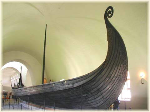
La nave rappresentava per i vichinghi la loro compagna e alleata
naturale, con essa potevano pescare, commerciare e comunicare con le terre
vicine, senza di essa non potevano sopravvivere. La nave vichinga accoglieva al
suo interno i guerrieri anche per l’ultimo viaggio nell’aldilà, il Valalla,
seppellita sotto un tumulo o bruciata su di una pira. Le navi, proprio per la
molteplicità dell’uso che ne fecero i vichinghi erano di vari tipi: da guerra,
da trasporto, da pesca, diverse imbarcazioni adatte secondo le diverse coste, a
seconda della dimensione per il tipo di propulsione a vela o a remi o entrambi,
navi adatte per il mare aperto fino all’atlantico settentrionale. Nel 1957, in
Danimarca nel fiordo di Roskilde vicino a Skuldelev, dei subacquei scoprirono un
muro di pietre di circa cinquanta metri e largo quattordici e sotto lo stesso
cinque relitti di navi vichinghe dell’undicesimo secolo. Le navi erano state
fatte affondare caricandole con pietre per impedire l’accesso al porto di
Roskilde ed il fondo fangoso ne ha mantenute quasi intatte le strutture. Due
navi erano da guerra, la più grande misurava ventiotto metri di lunghezza e
probabilmente a mezza nave cinque metri di larghezza; fra quelle scoperte finora
è sicuramente la più lunga e la più grande. Altre due erano da carico, la più
grande era profonda e a pieno carico pescava un metro e mezzo circa, aveva uno
spazio ben definito a mezza nave per le merci e ponti sopraelevati a poppa e a
prua praticamente uguali, alte e snelle con delle volute in legno artisticamente
lavorate che rappresentavano draghi o serpenti, da cui le navi presero nome di
Drakar o Snekkar. Sembra che per questa peculiarità, il senso di marcia delle
navi fosse indifferente. L’abilità degli scandinavi come costruttori e marinai
era leggendaria; avevano raggiunto un altro grado di perfezione tecnica, tanto
che lo storico Tacito nel novanta d.C. scriveva dei loro antenati:”Le loro navi
sono diverse. Con una prua a ciascuna estremità possono salpare facilmente.
Inoltre non usano le vele, fra l’altro senza un riscontro concreto, potrebbe
ascriversi piuttosto alle diverse tipologie di navi utilizzate dai germani
settentrionali, probabilmente quelle descritte da Tacito non le utilizzavano. Il
costume di utilizzare le navi come mezzo di trasporto nell’aldilà ci ha
lasciato, fortunatamente , numerosi reperti di imbarcazioni sotto centinaia di
colline di sepoltura in tutto il nord e questo ci ha permesso di verificare tipi
ed epoche delle navi vichinghe. Gli esempi classici sono: la nave di Tune,
probabilmente risalente alla fine del nono secolo, che fu portata alla luce nel
1867 da un terrapieno di sepoltura nel lato orientale del fiordo di Oslo; la
nave di Gokstad, di nuovo probabilmente della fine del nono secolo, ritrovata
nel 1880 in un sito di sepoltura sulla parte occidentale del fiordo, e la nave
di Oseberg, che fu scoperta nel 1903, anche essa nella parte occidentale dello
stesso fiordo. Queste tre navi famose, tutte e tre esposte al Museo Vichingo
delle navi a Bygdoy, vicino a Oslo, erano navi di sepoltura. La nave di Gokstad
rappresenta un esempio di nave da traversata: leggera nell’acqua, bella, veloce
quando lanciata al massimo e facile da trascinare a riva. Questa nave vichinga
completa fu rinvenuta dagli archeologi sotto una collinetta di cinque metri
Gokstad. Era stata preservata dalla creta azzurra sotto la quale era stata
sepolta e con la quale era stata riempita. Quando fu sepolta, probabilmente alla
fine del nono secolo, la nave di Gokstad poteva avere cinquant’anni; potrebbe
trattarsi quindi di una nave del primo periodo vichingo. La nave misura 23,33
metri di lunghezza e 5, 25 di baglio massimo e 1, 95 metri dalla chiglia alla
falchetta a mezza nave. Fatta interamente di quercia tranne che per il
rivestimento del ponte, l’albero e i pennoni, pesava circa 18 tonnellate e
probabilmente pescava poco meno di un metro, un pescaggio molto basso. La parte
straordinaria di questa nave è la sua chiglia; scavata in un unico tronco di
quercia, misura 17,6 metri in lunghezza e si assottiglia in profondità da 42
centimetri a mezza nave fino a 37 alle estremità. La quercia dalla quale è stata
ricavata la chiglia doveva essere alta circa 25 metri e necessariamente diritta.
Gli artigiani modellarono la chiglia a forma di morbido arco, più profondo in
centro di circa 25 centimetri rispetto alla prua e alla poppa. Ne risulta perciò
una nave poco profonda. La pressione dell’acqua contro la chiglia contrastava
con la pressione del vento sulla vela, impedendo così alla nave di capovolgersi.
Una volta predisposta la chiglia, vennero assicurati ad essa con perni di legno
i dritti di prua e di poppa, ciascuno dei quali era ricavato da un unico pezzo
di massello di quercia. Una volta collocati la chiglia e i dritti di prua e di
poppa, veniva assemblato il fasciame dello scafo ed in seguito venivano
collocate diciannove ordinate e altrettanti bagli in modo da tenere insieme lo
scafo. Ogni fiancata era costituita da sedici corsi di fasciame sovrapposto. La
prima tavola del fasciame su ciascuno lato portava sedici fori per i remi, che
potevano essere chiusi con dei sportellini di legno quando la nave andava a
vela. Sopra la prima tavola veniva collocata una spessa falchetta. Un rastrello
posto lungo la falchetta permetteva di appendere all’esterno trentadue scudi.
Sono stati infatti rinvenuti i reperti di sessantaquattro scudi nel sito di
Gokstad. Il rivestimento del ponte veniva appoggiato, e non attaccato ai bagli.
La nave era governata da un lungo timone, che non si trovava nella classica
posizione all’estremità della nave ma era assicurato ad un pezzo di legno,
chiamato blocco del timone, fissato sulla fiancata di dritta, verso la poppa. Da
momento che l’albero non si è preservato, non si può ricostruire la sua altezza
originale, e non si conosce quindi l’altezza precisa della vela, probabilmente
tra i 10 e 13 metri. L’albero era collocato in un altro grosso blocco di
quercia, la scassa, poggiato sulla chiglia a mezza nave e poteva essere
facilmente rimosso se le condizioni lo richiedevano. La vela era di forma
rettangolare, o forse quasi quadrata, probabilmente circa 11 metri quadrati ed
era ottenta cucendo insieme pezzi di lana grossa di forma quadrata o a strisce.
Era attaccata ad un pennone e le scotte che partivano dalla sua base
assicuravano la necessaria governabilità, sia navigando contro vento sia con il
vento in poppa. Tra gli anni 1892 e 1893 fu costruita una copia di questa nave,
chiamata The Viking, fu messa in mare ed in vent’otto giorni attraversò il
tratto da Bergen in Norvegia all’isola di Terranova, in America settentrionale.
La nave dimostrò una straordinaria flessibilità che le permise di torcersi fino
a 15 centimetri rispetto alla forma originale, il timone laterale si dimostrò
una soluzione ottima e da preferire a quello centrale, navigò bene anche con
condizioni meteorologiche avverse e raggiunse la meta a vele spiegate con
velocità non inferiore delle navi a vapore dell’epoca.
ESPLORAZIONI
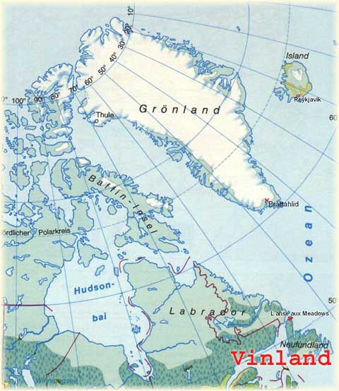
Terra
di viti e foreste
Per un lungo periodo di tempo i vichinghi si recavano in
nord America per fornirsi di legna che mancava nella colonia della
Groenlandia.
Eirik il Rosso era un uomo d’azione: insieme al padre fu
costretto a lasciare la propria casa in Norvegia sud occidentale dopo un
omicidio. Dopo essersi sistemato in Islanda, evidentemente non riuscì a
controllare il suo temperamento perché altre uccisioni lo fecero bandire
dall’Islanda per tre anni. Trascorse il tempo esplorando la terra oltre alcune
isole occidentali che un suo parente, Gumbjorn aveva avvistato durante un
viaggio tempestoso, che pensiamo si trovasse nella regione di Ammassalik, al
largo della costa sud orientale della Groenlandia. Ciò che Eirik vide dei fiordi
interni che penetravano dentro la costa sud occidentale della nuova terra, lo
convinse che era decisamente adatta all’agricoltura norvegese occidentale che
gli era familiare. In questo sistema, l’allevamento era combinato con la pesca e
la caccia di mammiferi marini e terrestri, che fornivano quasi tutto quello che
serviva per l’uso domestico ed il commercio. Egli chiamò l’area esplorata
Groenlandia ( Terra Verde ), come ci narrano le saghe, perché pensava che il
nome avrebbe attirato i coloni. E infatti arrivarono. Nel 986 o poco dopo Eirik
il Rosso raggruppò Thjodhild, la moglie proveniente da una famiglia agiata e dal
carattere indipendente, i tre figli Leif, Thorvald e Thorstein e la figlia
Freydis e guidò una flotta di 25 navi cariche di coloni, animali e masserizie.
Si dice che quattordici navi completarono il viaggio, ma devono essere raggiunte
da altre navi, perché ben presto non uno, ma ben due avamposti norreni fiorirono
in Nord Atlantico nella Groenlandia sud occidentale. La colonia principale e più
meridionale, nell’attuale regione di Julianehaab, fu chiamata Colonia Orientale,
mentre un area più piccola e più all’interno rispetto alla moderna capitale
della Groenlandia, Nuuk, prese il nome di Colonia Occidentale. Veterani del
mare, i norvegesi scoprirono presto che la costa occidentale della Groenlandia
si inclina notevolmente verso ovest mentre corre verso nord. Le testimonianze
archeologiche rivelano che i groenlandesi norvegesi veleggiarono anche più ad
ovest nel Nuovo Mondo, quasi cinquecento anni prima di Cristoforo Colombo. Non
solo frequentarono la costa di Labrador sia allora che in seguito, ma durante
quei primi viaggi giunsero forse a sud fino al fiume San Lorenzo, nei pressi
dell’attuale Nova Scotia. I Groenlandesi erano gente pratica ed i loro viaggi
erano spronati dalla necessità di acquisire risorse per le costruzioni navali ed
il commercio. Ma fino a che punto esplorarono e che cosa accadde infine di loro
è ancora avvolto nel mistero. La Saga di Eirik il Rosso, scritte in Islanda
almeno due secoli dopo gli avvenimenti che commemoravano e note collettivamente
come le Saghe di Vinland, sono vaghe in modo frustrante su quanto a sud
navigarono questi primi viaggiatori in Nord America. I moderni resoconti
archeologici suggeriscono che in seguito gli attraversamenti norvegesi si
concentrarono su regioni americane molto più a nord e indicano anche una serie
complessa di possibili ragioni per la fine della colonia della Groenlandia
norvegese intorno al 1500.
UNA COSTA STERILE
Mentre la dimensione e la
natura continentale del Nordamerica erano tanto ignote ai vichinghi quanto lo
stesso nome di America, essi vennero a sapere presto dell’esistenza delle
regioni costiere nord orientali, che si dice abbia individuato per primo
l’islandese Bjarni Herjolfsson. All’incirca nel periodo in cui Eirik il Rosso
stava cominciando la colonizzazione, Bjarni, secondo la Saga dei Groenlandesi,
salpò per raggiungere suo padre in Islanda, come era suo costume, dopo aver
passato l’inverno in Norvegia. Quando Bjarni seppe che suo padre era emigrato
verso ovest, si mise in mare per cercarlo; riuscì a trovare la nuova fattoria di
Herjolf, ma non prima di essere trascinato fuori rotta a sud ovest della
Groenlandia. Mentre navigava di nuovo verso nord per riguadagnare una latitudine
appropriata (di cui era stato chiaramente informato prima di partire), osservò a
ovest una lunga costa verdeggiante di foreste che cambiava gradualmente in un
paesaggio di rocce nude e neve. Oggi chiamiamo quella distesa brulla Isola di
Baffin. Secondo la Saga, Bjarni riferì questi avvistamenti dopo il suo arrivo in
Groenlandia. Il suo racconto dovrebbe aver dato ai suoi compagni norvegesi
valide ragioni di aspettarsi delle foreste in quella terra inesplorata
occidentale se veleggiava abbastanza a sud. Dato che il loro nuovo paese mancava
di alberi adatti a costruire le navi, le notizie di Bjorni devono devono essere
state le benvenute (se erano veramente notizie e non solo la versione artistica
rimaneggiata dell’autore della saga di parecchi avvistamenti casuali simili di
viaggiatori norvegesi). In ogni caso doveva combaciare con le esperienze che
quei primi abitanti della Colonia Occidentale avevano probabilmente messo
insieme mentre cacciavano i trichechi a nord della piccola comunità agricola. I
trichechi seguono il ghiaccio mentre si ritira durante la stagione estiva.
Mentre lo stretto di Davis si restringe prima di allargarsi nella Baia di
Baffin, il ghiaccio alla deriva tende a essere intrappolato, dando l’illusione
di un solido gomito costiero, descritto in tante mappe del XVI secolo di quella
regione. Mentre continuavano a seguire la selvaggina le navi norvegesi erano
costrette ad andare a ovest per restare in mare aperto. In queste circostanze i
cacciatori marini non potevano mancare di vedere i ghiacciai distanti dell’Isola
di Baffin e non ci sarebbe voluto molto a questi abili marinai a collegare
quell’alta costa con il racconto di Bjarni. Le testimonianze scritte di quei
viaggi all’estremo nord cominciano con la Historia Norvegiae del tardo XII
secolo, che riferisce che, nel lontano nord, i cacciatori groenlandesi si
imbatterono in gente di bassa statura che chiamarono Skraelings. Opinione comune
è che i norvegesi di Groenlandia aspettarono parecchie generazioni prima di
andare a cacciare a 73° di latitudine nord e probabilmente oltre a che la loro
forza propulsiva era il bisogno di merci da dare come tributo alla Chiesa. Ma
questo significa porre il carro davanti ai buoi. Fu in conseguenza dell’accesso
dimostrabile dei groenlandesi all’avorio di tricheco che la Groenlandia ottenne
il suo primo vescovo ufficiale nel 1124, dopo che un uomo di nome Einar Sokkason
portò zanne di tricheco e un orso polare vivo in Norvegia per ammorbidire re
Sigurd e i suoi funzionari ecclesiastici. Mentre il grasso dei mammiferi marini,
le pelli di tricheco, i corni di narvalo, le pellicce di orso polare ed altri
animali, piume di edredone (Somateria mollissima, un tipo di anatra, N.d.T.) e
girifalchi trovavano da tempo compratori in Europa, le zanne di tricheco davano
il migliore dei profitti per il disturbo di cacciarli. Pregiate in tutta
l’Europa settentrionale come sostituto di avorio di elefante, avevano il
vantaggio aggiuntivo di non essere deperibili e di essere facili da trasportare
per mare. Eirik il Rosso e i suoi coloni non devono aver dimenticato questa
realtà economica. Infatti il desiderio di ottenere queste merci preziose
probabilmente era la ragione principale per l’insediamento simultaneo della
Colonia Occidentale e di quella Orientale. La latitudine di quella Occidentale
la rendeva marginale per l’allevamento, ma era collocata strategicamente a metà
strada tra l’insediamento norvegese principale a sud ed il centro dei territori
di caccia settentrionali, l’Isola di Disko. Non dover viaggiare per altre 400
miglia dalla colonia principale prima di cominciare la caccia settentrionale in
estate avrebbe aumentato le possibilità di una stagione produttiva. Molto
probabilmente fu questo vantaggio che portò Eirik non solo a spingere per
istituire un insediamento a nord, ma anche a reclamare a Sandnes il sito
agricolo migliore e più strategico per la propria famiglia. La Saga di Eirik il
Rosso racconta che Thorstein Eiriksson, che probabilmente non ebbe il secondo
terreno migliore, era in parte proprietario di una fattoria a Lisufjord (Ora
chiamata Ameralla). La colonia Occidentale si sarebbe dimostrata strategica
anche per un altro tipo di impresa – le deliberate spedizioni per esplorare il
potenziale economico di quella sconosciuta terra occidentale.
VIAGGI A
VINLAND
L’iniziativa e la leadership delle spedizioni norvegesi – come sono
state raccontate nelle Saghe di Eirik il Rosso e dai Groenlandesi – appartenne a
Eirik e alla sua famiglia. Come gli islandesi medioevali, i groenlandesi avevano
una società gerarchica in cui dominavano i capitani. In Groenlandia Eirik era il
capo. I leader delle spedizioni, come membri dell’immediata cerchia di Eirik,
probabilmente usarono la sua fattoria a Sandnes come deposito in una rotta che
seguiva le coste su entrambi i lati per un lungo tratto e poi tagliava
attraverso lo stretto nel punto in cui si restringeva. Lo scopo di quelle
imprese altamente organizzate, presumibilmente, era il profitto ricavato dalle
risorse del Nuovo Mondo. L’archeologa canadese Birgitta Fallace teorizza – e
altri studiosi in genere concordano – che il sito vichingo di L’Anse aux Meadows
nella parte settentrionale di Terranova, fosse la strategica Porta su Vinland,
scelta dallo stesso Leif Eiriksson. Il sito di L’Anse aux Meadows (scoperto da
Helge e Anne Stine Ingstad nel 1960) fornisce la sola prova sicura di una
presenza vichinga in Nord America. Ma se questo dati archeologici sono
inconfutabili, non si può dire lo stesso per la collocazione o addirittura lo
stesso nome di Vinland, la regione più meridionale che Leif nominò. L’arida
terra settentrionale descritta da Bjiorni fu la prima che vide la spedizione di
Leif dopo il passaggio dalla Groenlandia ed egli le affibbiò il nome di
Helluland o Terra Lastra di Pietra. Quando raggiunse la vasta cintura di foreste
del Labrador – Terranova, Leif applicò il nome di Markland o Terra di Foreste.
Entrambi i nomi si riferivano a regioni costiere generali e riconoscibili, non
vi è alcun misticismo. Riguardo a Vinland, però, restano alcuni dubbi su quanto
a sud si spinsero i vichinghi e su dove all’incirca Leif decise che la Terra di
Foreste diventava Terra del Vino, dopo che un membro dell’equipaggiamento ebbe
riferito la scoperta di bacche da vino (Vinber, in antico norvegese). I
norvegesi sapevano che il tipo di bacche producevano vino; nell’anno 1000 erano
parecchie centinaia di anni che commerciavano con il continente ed i pirati
vichinghi per lungo tempo avevano svernato in Francia e nella Penisola Iberica,
dove di sicuro non avevano bevuto latte acido. Il nome Vinland, perciò,
suggerisce un luogo abbastanza a sud da essere entro il territorio delle viti
selvatiche. Ciò non vuol necessariamente dire andare oltre la riva meridionale
del fiume di San Lorenzo, dove comincia pure il territorio delle noci bianche
(Juglans cinerea)). Sia il frutto che il legno della Juglans Cinerea sono stati
trovati negli strati appartenenti alla cultura vichinga a L’Anse aux Meadows,
datati intorno all’anno 1000. E’ perciò ragionevole associare le viti a Vinland,
nonostante l’opinione di alcuni studiosi che sostengono che il prefisso Vin-
abbia in realtà una vocale breve e si riferisca a campi erbosi. Questa
interpretazione è stata favorita da quelli che vogliono far combaciare l’isola
di Terranova (dove c’è molta erba, ma nessuna vite selvatica in bella vista) con
la Vinland menzionata dalle saghe. Comunque, la moderna ricerca linguistica
contraddice questa interpretazione. Vin, riferendosi ai prati verdi, entrò in
disuso molto prima della colonizzazione dell’Islanda e della Groenlandia. Eirik
il Rosso non la applicò alla Groenlandia – un nome che coniò perché voleva che
la gente capisse il potenziale del paese per l’allevamento e perché sapeva che
in estate quei fiordi interni a sudovest sono coperti da un verde brillante. Non
conosceva né la forma né la dimensione del nuovo paese che voleva colonizzare,
ma ciò non importava né a lui né ai suoi seguaci, che comprendevano appieno la
pratica norvegese di dare il nome a un nuovo luogo per indicare che sarebbe
entrato bene nel loro sistema economico. Leif seguì lo stesso schema e nominò
ciascuna delle tre regioni americane per il loro potenziale economico. E’ dubbio
che lui o il suo equipaggio, che provenivano da un paese con pascoli
relativamente molto abbondanti si sarebbero entusiasmati abbastanza alla vista
di prati sul lato americano. I seguaci groenlandesi di Leif avrebbero
interpretato Helluland come Terra Così Così, Markland come Terra Utile e Vinland
come Terra di Lusso, per via delle viti, non dell’erba. A giudicare dalle saghe,
amerindiani ostili scoraggiarono la colonizzazione norvegese in aree abbastanza
a sud da permettere l’allevamento. Comunemente si suppone che perciò che i
viaggi vichinghi in America siano cessati assai presto, ma le testimonianze
archeologiche accumulate suggeriscono che successive generazioni di groenlandesi
norvegesi sfruttarono appieno le informazioni fornite da queste prime
esplorazioni e per parecchi altri secoli intrapresero viaggi stagionali per
valersi delle risorse americane.
IN CERCA DI FORESTE E TORBIERE FERROSE
Le
deperibili uve di Vinland non sarebbero valse la pena di futuri attraversamenti
per gente pratica come i norreni di Groenlandia. Pellicce e altre risorse
disponibili a sud del fiume di San Lorenzo avrebbero potuto essere ottenute da
Markland, lontano dal territorio indiano. I norvegesi avrebbero raggiunto la
Terra delle Foreste prima di arrivare al posto di svernamento di Leif a L’Anse
aux Meadows. Avrebbe avuto poco senso viaggiare più a sud del necessario per
trovare quello di cui avevano bisogno e cioà legname e probabilmente ferro. A
L’Anse aux Meadows i norreni fusero di torbiera in una fornace a pozzo e
trasformarono il ferro in chiodi per le navi. Per comunicare su distanze più
lunghe, pescare e cacciare e ottenere quello di cui avevano bisogno per la loro
economia interna ed estera, i norreni di Groenlandia dipendevano da barche e
navi. I resti archeologici confermano che essi costruirono i propri vascelli. I
norvegesi tradizionalmente costruivano le navi per la navigazione oceanica da
assi flessibili tagliate con l’ascia dal centro di tronchi attentamente
selezionati che fornivano ciascuno un asse perfetta. Le analisi del legno
praticate di recente su parti di navi trovate in entrambe le colonie
groenlandesi rivelano sei campioni di larice, un albero nativo solo in Siberia e
in Nordamerica. Se questi campioni non venissero dalle navi, si potrebbe
accettare la conclusione dello studio che il larice era probabilmente legno di
deriva proveniente dalla Siberia. Ma una spiegazione più semplice e più
probabile è che i vichinghi groenlandesi usassero il legno americano per le loro
imbarcazioni. Il Nordamerica è anche la fonte più probabile del ferro per i
chiodi o i rivetti indispensabili per legare le assi flessibili in corsi di
fasciame sovrapposti che creano la chiglia incredibilmente adatta al mare di una
nave norvegese. Gli scavi a L’Anse aux Meadows dimostrano che i norvegesi
padroneggiavano tutti gli stadi della lavorazione del ferro. I laboratori da
fabbro groenlandesi rivelano che anche là essi rimuovevano le scorie dai
lingotti di minerale di ferro e forgiavano prodotti finiti. Ma non potevano
fondere il ferro in fornaci a pozzo, dato che non c’era minerale di torbiera
locale, come non c’erano foreste che fornissero il legname per le navi.
Comunque, entro la regione di Markland – nel riparato angolo sudoccidentale
della Baia di Ungeva canadese – la foresta di abeti neri e larici arriva
praticamente fino al mare. Vicino o addirittura in superficie, buon minerale
ferroso di torbiera del filone del Labrador raggiunge anche esso la spiaggia,
pronto per essere fuso con la carbonella ottenuta dal legno tagliato di fresco,
come esigeva il metodo norreno. Un viaggi di andata e ritorno durante la
stagione in mare aperto (dalla tarda estate fino all’autunno inoltrato) sarebbe
certamente stato gestibile per gente abituata a navigare per lunghe distanze in
navi aperte e avrebbero avuto abbastanza tempo a terra per terminare i loro
compiti anche se non vi passavano l’inverno, cosa che non vi è alcuna ragione
logica o archeologica per pensare che lo facessero. Non sono state scoperte in
nessuna parte del Canada continentale orientale strutture permanenti del genere
di quelle di L’Anse aux Meadows, mentre in questa regione vi sono numerose
rovine di abitazioni eschimesi medievali, che molto probabilmente si sarebbero
sentiti minacciati se i norreni avessero eretto case invernali nella loro area.
Inoltre l’identità culturale dei norvegesi groenlandesi era così strettamente
legata all’allevamento che è improbabile che avessero lasciato le loro dimore in
un certo numero per assumere residenza permanente nella baia di Ungeva come
cacciatori o taglialegna.
PROVE DI ATTRAVERSAMENTO SUCCESSIVE
Sarebbe
difficile trovare tracce archeologiche di accampamenti vichinghi, soprattutto
perché la terra della Baia di Hudson è salita molto negli oltre tre secoli
trascorsi. Qualsiasi traccia di tende, fuochi di accampamento e depositi di
rifiuti norvegesi sarebbe ora ricoperta da vegetazione. Comunque, sembra che
l’opera tardo medievale perduta “Inventio Fortunae” descrivesse un attività
sulla spiaggia dei norreni sul lato occidentale dello Stretto di Davis. Si dice
che l’opera registri le esperienze di un frate minorita inglese che viaggiò per
mare fino alla Groenlandia intorno al 1360; continuò verso nord esplorando la
costa settentrionale e scese giù per l’isola di Baffin, coste che probabilmente
sperimentò come un'unica cosa. Il frate incontrò gli eschimesi pigmei in una
terra vuota di gente, eccetto sul lato passato dove in quella stretta terra
terra (itsmo) c’erano 23 persone non più alte di 1,20 m. Correlate con la
moderna scienza archeologica dei siti medievali eschimesi, la descrizione
suggerisce si tratti della parte sud orientale dell’isola di Baffin. In quei
luoghi più all’interno da dove il minorita aveva visto gli eschimesi pigmei egli
trovò un gran pezzo di fasciame di nave e altri pezzi che erano stati usati in
grandi navi, oltre a molti tronchi d’albero che in un periodo precedente erano
stati abbattuti, cosa che considerò una prova di precedente abitazione umana. In
un sito eschimese thule del XIII secolo, anche esso sulla costa meridionale
dell’Isola di Baffin, l’archeologa Deborah Sabo trovò una scultura in avorio di
tricheco che rappresenta un europeo vestito con una lunga tunica in un pezzo con
un apertura davanti e una croce intagliata sul petto. Difficilmente è l’abito
di un cacciatore o un agricoltore pescatore. Gli studiosi non sono d’accordo se
rappresenti un norvegese o solamente un europeo medievale. Un indicazione più
affidabile di una continua attività norvegese in questa regione sono tre voci
del 1347 nella collezione “Annali Islandesi” (il primo dei quali fu scritto nel
XIII secolo), che parlano di una piccola nave con 17 o 18 groenlandesi a bordo
che aveva raggiunto l’Islanda dopo essere andata fuori rotta mentre tornava da
Markland verso casa in Groenlandia. La mancanza di ulteriore elaborazione indica
che sia il nome del luogo che lo scopo del viaggio avrebbero dovuto essere
evidenti per i compagni islandesi degli annalisti. Il cimitero a Sandnes, nella
Colonia Occidentale, conteneva una punta di freccia di selce proveniente dalla
baia Ramah o da quella di Ungeva e di uno stile che suggerisce che i fabbricanti
fossero indiani abitanti il Labrador meridionale o Terranova tra il 1000 e il
1500. Il cimitero è cristiano, il che pone la morte di chi fu colpito dalla
freccia molto dopo i viaggi di cui leggiamo nelle saghe e l’oggetto è associato
con la regione di Ungeva e l’adiacente costa orientale canadese. Un sito indiano
del XII secolo sulla costa del Maine ha svelato una moneta norvegese coniata nel
periodo 1095 – 1315 (le date differiscono da quelle di altri autori, N.d.T.).
Pelo di bisonte e di orsi neri o bruni fu scoperto alla Fattoria Sotto la
Sabbia, un sito della Colonia Occidentale scavato di recente e abbandonato a
metà del XIV secolo. E’ improbabile sia di origine Europea: anche questi peli di
animali non groenlandesi suggeriscono continui passaggi norreni verso il Nord
America. Scavi completati di recente sull’altro lato dello stretto di Davis
aggiungono altri dettagli alla nostra storia. I siti dell’Isola di Baffin
investigati in connessione con i viaggi di Martin Frobisher nel 1576 – 1578,
rivelarono due attenti arrangiamenti di mandibole di tricheco, uno datato 1460 –
1520, con i denti estratti, sull’isola di Willow. Parecchi lingotti di ferro
medievali sono stati trovati sull’isola di Kodlunarn e altri siti intorno al
Countess of Warwick Sound. Non esistono associazioni note tra arrangiamenti di
mandibole di tricheco e i dorset o i thule su entrambi i lati dello stretto di
Davis, ma più di venti mandibole sistemate con cura con i denti estratti erano
sepolte proprio fuori del muro della cattedrale norvegese a Gardar, su suolo che
i norvegesi avevano portato dentro per il cimitero. I lingotti di ferro trovati
ai siti Frobisher hanno caratteristiche coerenti con il minerale di torbiera e
le origini medievali, ma nell’area non esisteva alcuna fornace a pozzo. Non c’è
da meravigliarsi – l’isola di Baffin è priva di minerale di torbiera quanto la
Groenlandia. Le date al radiocarbonio eseguite su alcuni dei lingotti cadono
entro il periodo dell’occupazione norvegese della Groenlandia e un analisi dei
frammenti di carbone in uno di questi lingotti identificava quattro specie di
legno che probabilmente fossero usate dai norvegesi se lavorando il minerale
ferroso di torbiera nella regione meridionale della baia di Ungava: abete,
larice, betulla e ontano. Sono necessari test metallurgici su questi lingotti e
su campioni di ferro provenienti dalla Groenlandia norvegese per determinare se
la loro composizione chimica concorda con il filone ferroso del Labrador.
Un
analisi completa di quattro pezzi di ferro semilavorato, trovati tra le rovine
di una grande fattoria interna della Colonia Orientale aumenterebbe anche essa
la nostra comprensione della vita dei groenlandesi e del loro destino. Questi
pezzi sono diversi da qualsiasi ferro prodotto da coloni norreni o dagli stessi
norvegesi scandinavi prima del 1500. Furono trovati nello strato superiore e
perciò sono associati con l’ultima fase della colonia e corrispondono ai pezzi
di ferro usati nel commercio inglese del merluzzo con l’Islanda del XV
secolo.
LA RICERCA INGLESE DEL MERLUZZO
Lo stile del XV secolo degli abiti
trovati nei cimiteri groenlandesi indica l’arrivo di visitatori stranieri anche
dopo la rottura dei contatti con la Norvegia intorno al 1400. Altre
testimonianze archeologiche provenienti dall’ultima fase – un coltello da
tavola, un pendente a croce di peltro, una croce di giaietto e quei quattro
pezzi di ferro non lavorato – puntano all’Inghilterra e suggeriscono un
commercio che comprendeva il vicino più prossimo alla Groenlandia, l’islanda.
Ciò non sarebbe irragionevole dato che i norvegesi medievali erano esperti nella
pesca e nella conservazione del pesce essiccato all’aria. Le fattorie e le
chiese groenlandesi vuote, ma ordinate, alla fine del secolo fanno pensare a una
partenza programmata e tranquilla. Date le prove sempre maggiori dell’ostilità
del clima, dei campi trascurati e di una dieta sempre più marina durante
l’ultima fase dei norvegesi groenlandesi, può essere che di fronte alle
difficoltà sempre maggiori verso la fine del XV secolo, i restanti groenlandesi
norvegesi si siano convinti a unirsi a un impresa inglese o anglo portoghese,
aspettandosi di vivere come provetti pescatori contadini in un area protetta
abbastanza a nord e a est lungo la costa di Terranova e/o Labrador da evitare
scontri con gli spagnoli sulla linea del Trattato di Tordesillas del 1494.
Sfortunatamente, la maggioranza dei primi tentativi di colonizzazione lungo
quella parte della costa americana finirono nel disastro. I norvegesi non
lasciarono mai un ricordo cartografico – dai viaggi a Vinland in poi – della
loro familiarità con la costa nord orientale dell’America. Entro un secolo dalla
riscoperta dell’America, però, ci furono tentativi di ricostruire le navigazioni
norrene medioevali sulla base della saghe e di mappe create altrove in Europa,
mentre aumentavano le informazioni su quelle spiagge lontane. Particolarmente
importanti tra queste ricostruzioni sono le mappe fatte dagli islandesi Siguròur
Stefansson, nel 1590 circa e Gudbrandur Thorlaksson nel 1606, quest’ultima in
relazione con la prima delle tre spedizioni di re Cristiano IV di Danimarca
inviate a reclamare i sudditi norvegesi che egli pensava di avere ancora in
Groenlandia. Tra le prime mappe non scandinave che mostrano la regione dello
stretto di Davis, due hanno uno speciale interesse per noi; una è la Mappa Mundi
che Johannes Ruysch fece per l’edizione romana del 1507 – 1508 della “Geografia”
di Tolomeo; l’altra è la mappa del 1527 che Robert Thorne il Giovane disegnò per
dimostrare dove suo padre era andato in Nord America con il suo socio nel 1494.
Anche se imperfette, queste descrizioni della costa orientale canadese e della
Groenlandia riflettono le ricerche inglesi dei banchi di merluzzo in quella
regione, una ricerca che implicava la conoscenza della Groenlandia mentre i
norvegesi erano ancora là e che può essere la chiave di ciò che accadde alla
fine a un popolo che cinque secoli prima aveva scoperto Bacche da Vino mentre
cercavano la Terra delle Foreste.
Le Saghe di Vinland
Le saghe di Vinland,
che comprendono due opere separate scritte in modo indipendente in Islanda
all’inizio del XIII secolo, la Saga dei Groenlandesi e la Saga di Eirik il
Rosso, narrano il racconto di parecchi viaggi al di là dell’Atlantico
settentrionale al culmine dell’Età Vichinga (800-1050 d.C.), organizzati intorno
all’anno 1000 da gente proveniente dall’Islanda e dalla Groenlandia. Esistono
riferimenti precedenti che mostrano come i viaggi a Vinland fossero noti in
Islanda e nel continente europeo prima
che le due saghe fossero scritte:
Adamo di Brema scrisse una storia degli arcivescovi di Amburgo in cui riferisce
informazioni ricevute nel 1068 o 1069 dal re danese Svein Ulfsson su un’isola di
nome Vinland, dove crescevano le viti e il frumento selvatico (in realtà avena
selvatica) e un accenno più breve appare nel Libro degli Islandesi di Ari il
Saggio, la prima storia d’Islanda scritta tra il 1122 e il 1133. Ari narra che
Erik il Rosso aveva trovato resti di abitazioni in Groenlandia simili a quelle
degli skraelings di Vinland.
Le saghe non sono racconti di testimoni oculari,
ma trascrizioni di tradizioni orali di discendenti di marinai che usavano
tramandarsi informazioni nautiche su come raggiungere luoghi lontani, con i
punti di riferimento preferibilmente inseriti come parte integrante di storie,
secondo l’uso delle culture tradizionali. Per questo motivo non possono essere
trattate come documenti storici contemporanei, ma non possono essere ignorate
dagli storici perché i fatti e le informazioni generali che contengono sono
confermati dall’archeologia. Le saghe sono un misto di fatti e fantasia, ma non
sono opere di pura finzione letteraria
né miti o leggende. Esistono due
varianti della Saga di Eirik il Rosso, il Libro di Skálholt e i Libro di Hauk,
che rappresenta l’edizione più manipolata. La più importante differenza tra la
Saga dei Groenlandesi e quella di Erik è data dal fatto che le quattro
spedizioni dei Groenlandesi sono fuse in una sola. In quella di Erik. Thorfinn
Karlsefni ha assunto il ruolo di Leif Eiriksson come capo della spedizione che
dà i nomi alle nuove terre, mentre Leif è relegato alla scoperta occasionale
iniziale, ma per il resto gli eventi sono quasi identici. Le saghe furono
composte con propositi diversi: quella dei Groenlandesi fu scritta per dare un
resoconto storico alle esplorazioni di Vinland, mentre quella di Eirik intendeva
rendere omaggio a Gudrid, moglie di Karlsefni e appoggiare la canonizzazione dei
loro discendenti, il vescovo Bjorn Gilsson di Hólar e il vescovo Brundur
Saemundarson. Ciò spiega la magnificazione del ruolo di Karlsefni, che è ancora
più evidente nella versione Hauk, il cui curatore, Hauk Erlendsson, era un
diretto discendente di Karsefni e Gudrid.
Le saghe mostrano un mondo ancora
in gran parte pagano, che prega Thor ma dove è giunto da poco il cristianesimo e
le due religioni convivono in casa di Eirik, che adora ancora gli antichi dei,
ma permette alla moglie, convertita dal figlio Leif, di costruire una chiesetta.
I vichinghi avevano anche schiavi, germani o scozzesi, che utilizzavano come
esploratori avanzati, maschi e femmine e usavano scudi bianchi per segnalare
pace e commercio e rossi per indicare la guerra. Sappiamo che le loro donne
potevano essere assai temibili: Freydis, figlia naturale di Eirik, oltre a
tessere intrighi e assassini, appare come una valchiria che mette in fuga gli
indigeni durante la battaglia, quando, incinta, esorta i suoi e, circondata,
afferra la spada di un caduto: « Allora gli skraelings piombarono su di lei;
ella trasse il seno dalla veste e con la spada sguainata si mise a menar
fendenti. Davanti a tale reazione gli skraelings si meravigliarono, corsero alle
barche e remarono via» ( Saga di Eirik il Rosso). Quanto agli indigeni, che i
vichinghi consideravano “deboli”, come dice il soprannome skraeling, amavano la
stoffa rossa quanto i loro discendenti parecchi secoli dopo, usavano canoe di
pelle come i micmac del XVII secolo e, come quelli, catapultavano proiettili
contro i nemici.
|
|
|
|
|
|
 | |


